2006
The
What
Boise METROGAIN is an orienteering event spanning multiple
mapped regions in and around
Registration
Pre-register by sending email to savelichko@yahoo.com before October 11 so we can pre-print maps for you. State your name and the course you selected (Long or Short). You don’t need to pre-register for Beginner course. You will need to fill out a registration form before your start so give yourself an ample amount of time for the final registration and warmup before the race starts at 11 am on October 14.
Courses
This year courses offer Long, Short, and Beginner options. Long course is suited for experienced athletes. Short course is suited for experienced juniors, women, and elderly athletes. Beginner course is suited for first comers and families with small kids. You have an option to explore on foot or use your mountain bike.
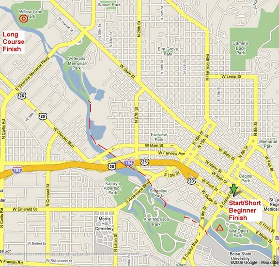
Long course (suited for experienced athletes) starts at the rotunda in Julia Davis park, goes through the park and BSU campus, continues for the short 500m along the Greenbelt to the Ann Morrison park, goes around Ann Morrison park, continues along the Greenbelt for about 2 km to the Veterans park, goes around Veterans and Willow Lane parks, and finishes in the Willow Lane park. See the map for the course layout. First leg will be on easy side as it shares with the short course. Course statistics (length and number of controls are tentative to give a sense of what to expect):
|
Leg # |
Park Name |
Length km |
## Controls |
Map Scale |
|
1 |
Julia Davis Park/BSU Campus |
3 |
10 |
1:7500 |
|
2 |
Path to |
0.5 |
|
|
|
3 |
|
3 |
10 |
1:5000 |
|
4 |
Path to |
2 |
|
|
|
5 |
Veterans/Willow Lane Parks |
6 |
20 |
1:7500 |
|
|
Total: |
14.5 |
40 |
|
Climb is negligible. Expected winning time on the long course is 1:30 hours.
Short course (suited for experienced juniors, women, and elderly athletes) starts at the rotunda in Julia Davis park, goes through the park and BSU campus, continues for the short 500m along the Greenbelt to the Ann Morrison park, goes around Ann Morrison park, and returns back to the Julia Davis Park for the couple last controls. It shares first leg and somewhat shares second leg with the Long course. See the map for the course layout. Course statistics (length and number of controls are tentative to give a sense of what to expect):
|
Leg # |
Park Name |
Length km |
## Controls |
Map Scale |
|
|
1 |
Julia Davis Park/BSU Campus |
3 |
10 |
1:7500 |
|
|
2 |
Path to |
0.5 |
|
|
|
|
3 |
|
3 |
10 |
1:5000 |
|
|
4 |
Path back to |
0.5 |
|
|
|
|
5 |
|
0.5 |
2 |
1:7500 |
|
|
|
Total: |
7.5 |
25 |
|
|
Climb is negligible. Expected winning time on the short course is 1:15 hours.
Beginner course (suited for first comers and families with small kids) starts at the rotunda in Julia Davis park, goes through the park and BSU campus, and finishes back at rotunda. Length of the course would be around 3 km.
Maps
Maps of Julia Davis Park/BSU Campus (1:7500), Ann Morrison park (1:5000), and
Awards
First three places in each Long, Short, and Beginner courses will be awarded with special prizes. Honorable awards to female athletes on Long course, and, of course, our kids.
Start
Start will be Saturday October 14 at 11:00 am sharp at the
rotunda in the
What to Expect at the
Start
10 minutes before the start (10 minutes before 11 am) all are called to the start line for the instructions.
2 minutes before the start all receive competition packets that include course layout map, clearly marked maps for each leg with pre-printed controls and punch boxes, and control clue sheet.
1 minute before start all allowed opening their competition packets.
At 11:00 am mass start is given.
Punching
Please punch at each control in corresponding boxes on your
maps. For example, punch first 10 controls in Julia Davis Park/BSU Campus on
Julia Davis/BSU Campus map in designated punch boxes. Punch next 10 controls in
Fees
To cover costs you will be charged:
- Long and Short course $10 non-members and $5 members.
- Beginner course fees are our regular.
Transportation and
Babysitting
No babysitting is offered. Please consider parking and
carpooling from the finish area at Willow Lane Park to the start in
Water
Drinking water will be available at the start and finish, as
well as one each control with water in
Hazards
It may be cold – dress according to the weather. Have a
change of the clothes at your designated finish (
If you chose to use bike on the course you are required to wear proper protective attire including approved helmet.
Directions
More information and maps are available at our web site:
http://www.ctoc-boise.org/ctoc/maps.htm
Park and BSU are located at the beautiful Boise Greenbelt
along the
For out of
I-84 to I-184 connection (Exit #??). Take I-184 toward city center. Drive along
of I-184 (about 3-4 miles). I-184 will merge into Myrtle St. Keep in the right
lane and go straight East passing about 5 lights (13th, 11th, 10th, 9th,
Willow
Lane Park,
Park and Sport Complex is located
Between
Meet center is usually at the parking lot closest to the
For out of
I-84 onto Orchard St Exit in