2004
The
What
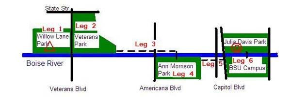
Boise METROGAIN is an orienteering event spanning multiple
mapped regions in and around
Registration
Pre-register by sending email to savelichko@yahoo.com (or call 377-4213) before November 17. State the course you selected (Long or Short).
Courses
This year courses offer Long and Short options. Beginner course for first comers and families with small kids will be also available. You have an option to explore on foot or use your road or mountain bike. Using bike will require doing last meters to the controls on foot as not all controls are accessible right from the paths.
Long course (suited for experienced athletes) starts in the
|
Leg # |
Park Name |
Length km |
## Controls |
Map Scale |
|
1 |
|
1.7 |
10 |
1:5000 |
|
2 |
|
2.3 |
10 |
1:5000 |
|
3 |
Path to AM Park |
2 |
|
|
|
4 |
|
3.7 |
10 |
1:5000 |
|
5 |
Path to |
0.5 |
|
|
|
6 |
|
3.6 |
10 |
1:7500 |
|
|
Total: |
13.8 |
40 |
|
Climb is negligible. Expected winning time on the long course is 1.5 hours.
Short course (suited for experienced juniors, women, and
elderly athletes) starts in the
|
Leg # |
Park Name |
Length km |
## Controls |
Map Scale |
|
1 |
|
1.7 |
10 |
1:5000 |
|
2 |
|
2.6 |
10 |
1:5000 |
|
3 |
|
1 |
5 |
1:5000 |
|
|
Total: |
5.3 |
25 |
|
Climb is negligible. Expected winning time on the short course is 1 hour.
Maps
Here are samples of the maps that will be used for the METROGAIN. Click on icons to get bigger images.
|
|
|
|
Julia Davis Park/BSU Campus |
|
|
|
|
|
![[Willow]](WillowMap.jpg)
![[Veterans]](VeteransMap.jpg)
![[Ann Morrison]](AnnMorrisonMap.jpg)
![[Julia Davis]](JuliaDavisMap.jpg)
Awards
First three places in each Long and Short courses (combined
for Foot, Bike, GPS, or gender subdivisions) will be awarded with special
prizes. Honorable awards to female athletes on Long course,
and, of course, our kids. Awards will be presented at the finish of the corresponding courses.
Start and Finish
Start will be Saturday November 20 at noon sharp from the Southern parking lot (closest to the river) in the Willow Lane Park. PLEASE ARRIVE EARLIER TO GIVE TIME FOR FILLING OUT SOME PAPERWORK (5 MINUTES MAX) AND WARMUP! It is advisable that you arrive to the start at least at 11:30 am. Finish of the Long course is close to the Zoo in the Julia Davis Park. Finish of the Short course is right at the start in the Willow Lane Park. Maximum allowed time on a course is 3 hours so all finishes will close promptly at 3 pm.
What to Expect at the
Start
10 minutes before the start (10 minutes before
2 minutes before the start all receive competition packets that include course layout map, clearly marked maps for each leg with pre-printed controls, GPS coordinates for each control, punch card(s), and control clue sheet.
1 minute before start all allowed opening their competition packets.
At
Punching
You will receive one (for short course) or two (for long course) punch cards. Please punch at each control in corresponding boxes. You will surrender punch cards at the finish so we can verify that you found all controls on your course.
Fees
You will be charged our standard fees of $2/map for members of the club ($3/map for non-members) to cover costs. That amounts to $8/member ($12/non-member) for Long course, and $4/member ($6/non-member) for Short course. Beginner course fee is our standard.
Transportation and
Babysitting
No babysitting is offered. Please consider parking and
carpooling from the finish area near the Zoo at the
Water
Drinking water will be available at the start and finish, as well as at the end of each leg. Water stops will be at the last control of each leg. They will be marked on the maps with drinking glass symbol.
Hazards
It may be cold – dress according to the weather. Have a
change of the clothes at your designated finish (
If you chose to use bike on the course you are required to wear proper protection attire including approved helmet.
Directions
More information and maps available at our web site:
http://www.ctoc-boise.org/ctoc/maps.htm
Park and Sport Complex is located
Between
Meet center is usually at the parking lot closest to the
For out of
I-84 onto Orchard St Exit in
Park and BSU are located at the beautiful Boise Greenbelt
along the
For out of
I-84 to I-184 connection (Exit #??). Take I-184 toward city center. Drive along
of I-184 (about 3-4 miles). I-184 will merge into Myrtle St. Keep in the right
lane and go straight East passing about 5 lights (13th, 11th, 10th, 9th,
GPS Coordinates of All Controls
CLICK HERE TO GET GPS COORDINATES OF ALL CONTROLS BY COURSE.