2005 Boise METROGAIN

The Foothills Challenge


What

Boise METROGAIN is an orienteering event spanning multiple mapped regions in and around Boise on the same date. It is designed to give an opportunity for the orienteering fans to experience long courses. On foot or on bike, you will try to find multiple controls along the lengthy course.


Registration

Pre-register by sending email to savelichko@yahoo.com before October 13 so we can pre-print maps for you. State the course you selected (Long or Short).


Courses

This year courses offer Long, Short, and Beginner options. Long course is suited for experienced athletes. Short course is suited for experienced juniors, women, and elderly athletes. Beginner course is suited for first comers and families with small kids. You have an option to explore on foot or use your mountain bike.


Long course (suited for experienced athletes) starts at the Hull’s Gulch area, continues to the Camelback Park, continues for the short quarter mile along the Parkhill Dr to the Stewart Gulch area, goes through the Stewart Gulch, and finishes by the Hillside Junior High School. See the map for the course layout. First leg will be on easy side as it shares with the short course. Course statistics (length and number of controls are tentative to give a sense of what to expect):


Leg #

Area Name

Length

km

## Controls

Map Scale

1

Hull’s Gulch

3.5

7

1:15000

2

Camelback Park

3

6

1:10000 (photo)


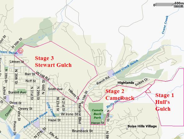
Path to Stewart Gulch

0.5


3

Stewart Gulch

3

7

1:10000


Total:

10

20


Course is quite hilly. Expected winning time on the long course is 1.5 hours.


Short course (suited for experienced juniors, women, and elderly athletes) starts at the Hull’s Gulch, continues to the Camelback Park, and returns back to the parking place at the Hull’s Gulch for the finish. It shares first leg and somewhat shares second leg with the Long course. See the map for the course layout. Course statistics (length and number of controls are tentative to give a sense of what to expect):


Leg #

Area Name

Length

km

## Controls

Map Scale

1

Hull’s Gulch

3.5

7

1:15000

2

Camelback Park

2.5

6

1:10000 (photo)


Total:

6

13


Course is quite hilly. Expected winning time on the short course is 1 hour.


Maps

Hull’s Gulch map is color printed at 1:15000 scale. Camelback area will be presented by black and white aerial photo with overlaid additional information (showing, for example, out of bounds and dangerous areas). The photo will be aligned with magnetic lines. The photo scale is 1:10000. Stewart Gulch map is color printed at 1:10000 scale. Both Hull’s Gulch and Stewart Gulch areas were used once or twice a year for local meets. Below are samples of the maps and aerial photo of Camelback that will be used for the METROGAIN. Click on map to get bigger image.


Hull’s Gulch

Camelback Park

Stewart Gulch

  [Hull's Gulch]

  [Camelback Park]

  [Stewart Gulch]


Awards

First three places in each Long and Short courses (combined for Foot, Bike, or gender subdivisions) will be awarded with special prizes. Honorable awards to female athletes on Long course, and, of course, our kids.


Start

Start will be Saturday October 15 at 11 AM sharp from the Hull’s Gulch parking lot. Competition will be held no matter what! Even bad weather would not spoil our determination! The parking lot is located at the end of 8th street 1 mile North past pavement ends.


What to Expect at the Start

10 minutes before the start (10 minutes before 11 AM) all are called to the start line for the instructions.

2 minutes before the start all receive competition packets that include course layout map, clearly marked maps for each leg with pre-printed controls, punch card, and control clue sheet.

1 minute before start all allowed opening their competition packets.

At 11 AM mass start is given.


Punching

You will receive one punch card. Please punch at each control in corresponding boxes. You will surrender punch cards at the finish so we can verify that you found all controls on your course.


Fees

Long and Short Courses:

Members of the club are charged $5 (with $5 discount).

Non-members of the club are charged $10.

Juniors non-members are charged $5.

Juniors members of the club are free of charge.


Beginner course participants are charged our standard $5 ($3 juniors) non-members and free for members of the club.


Transportation and Babysitting

No babysitting is offered. Please consider parking and carpooling from the finish area near the Hillside Junior High School (Hill Rd and 36th Street) to the start at Hull’s Gulch. It is your responsibility to arrange for the transportation.


Water

Drinking water will be available at the start and finish, as well as at the end of each leg. Water stops will be marked on the maps with drinking glass symbol.


Hazards

It may be cold – dress according to the weather. Have a change of the clothes at your designated finish (Hull’s Gulch for short course and Hillside Junior High School for long course). Stay hydrated – water is provided on the course. Plan to take some food with you on the course – you will need those extra calories. Hillsides may be slippery. Shoes with spikes for out-of-trails running or orienteering are recommended. On the course you may cross major transportation roads (8th Street, Highland View, and Bogus Basin Rd). Please be very cautious while crossing them!  If you chose to use bike on the course you are required to wear proper protection attire including approved helmet.


Directions

More information and maps available at our web site:

http://www.ctoc-boise.org


Hull’s Gulch, Boise, Idaho (Start and Short/Beginner Course Finish)

Terrain is located at the foothills of Boise. Meet center usually at the parking area approximately a mile North on 8th Street after the pavement ends.
For out of Boise commuters:
I-84 to I-184 connection. Take I-184 toward city center. Drive along of I-184 (about 3-4 miles). Turn left at the first light onto 13th street. Continue North along 13th St passed Fort St. to Lemp St (one block before Camelback Park). Take right on Lemp St. to 8th St (4 blocks). Go left on 8th. Go North to the parking area approximately a mile after the pavement ends. It takes approximately 15 minutes from I-84.


Hillside Junior High School, Boise, Idaho (Long Course Finish)

Finish at the North-East corner of the Junior High (behind the school). The school entrance is at the corner of Hill Road and 36st Street.
For out of Boise commuters:
I-84 onto Orchard St Exit in
Boise (Exit #52). Take North along Orchard St. Pass Franklin Rd, Fairview Rd intersections; go down to Chinden Blvd (it takes about 10 minutes from I-84). Take left on Chinden Blvd. Drive West 2-3 minutes along Chinden Blvd to Veterans Memorial Pkwy. Take right onto Veterans Memorial Pkwy. You will pass the Veterans State Park on the right. Continue straight through State St. onto 36th St. Go North on 36th St to Hill Rd. From there proceed to the school entrance.